Explore the detailed analysis of NCERT Geography Class 6 Chapters 1 to 8 in bilingual (Hindi and English), covering topics like Earth’s structure, climate, vegetation, wildlife, and more. Perfect for UPSC and school exam preparation.
Table of Contents
📘 Chapter 1: The Earth in the Solar System | अध्याय 1: सौरमंडल में पृथ्वी
🔹 Universe | ब्रह्मांड
- The universe is everything that exists – including stars, planets, galaxies, dust, and gases.
ब्रह्मांड वह सब कुछ है जो अस्तित्व में है – जैसे तारे, ग्रह, आकाशगंगाएँ, धूल और गैसें। - Our galaxy is called the Milky Way or Akash Ganga.
हमारी आकाशगंगा को मिल्की वे या आकाश गंगा कहा जाता है।
🔹 Celestial Bodies | खगोलीय पिंड
- Stars (तारे): Big balls of hot gases that emit light and heat (e.g., Sun).
गर्म गैसों के बड़े गोले जो प्रकाश और ऊष्मा उत्सर्जित करते हैं (जैसे सूरज)। - Planets (ग्रह): These do not emit their own light and revolve around a star.
ये खुद प्रकाश नहीं देते और किसी तारे की परिक्रमा करते हैं। - Satellites (उपग्रह): These revolve around planets. The Moon is Earth’s natural satellite.
ये ग्रहों की परिक्रमा करते हैं। चंद्रमा पृथ्वी का प्राकृतिक उपग्रह है। - Asteroids (ग्रहाणु): Found between Mars and Jupiter.
मंगल और बृहस्पति के बीच पाए जाते हैं। - Meteoroids (उल्कापिंड): Small pieces of rocks flying through space.
अंतरिक्ष में उड़ते हुए छोटे पत्थरों के टुकड़े।
🔹 Solar System | सौरमंडल
- The Sun is at the center of the solar system.
सूर्य सौरमंडल के केंद्र में स्थित है। - It consists of 8 planets, asteroids, moons, and comets.
इसमें 8 ग्रह, ग्रहाणु, चंद्रमा और धूमकेतु होते हैं। - Order of planets from the Sun:
सूर्य से ग्रहों का क्रम: Mercury, Venus, Earth, Mars, Jupiter, Saturn, Uranus, Neptune - Mnemonic: My Very Educated Mother Just Served Us Noodles
इसे याद रखने का तरीका।
🔹 Earth – The Unique Planet | पृथ्वी – एक अनोखा ग्रह
- The only planet known to support life.
एकमात्र ग्रह जहाँ जीवन संभव है। - Has water, suitable temperature, breathable air.
यहाँ जल, उपयुक्त तापमान और सांस लेने योग्य वायु है। - Appears blue from space due to water – hence called the Blue Planet.
अंतरिक्ष से नीला दिखता है – इसलिए इसे नीला ग्रह कहते हैं।
🔹 Moon | चंद्रमा
- Earth’s natural satellite.
पृथ्वी का प्राकृतिक उपग्रह। - Reflects sunlight – does not have its own light.
यह सूर्य के प्रकाश को परावर्तित करता है – इसका अपना प्रकाश नहीं होता। - Takes about 27.3 days to complete one revolution around Earth.
पृथ्वी की एक परिक्रमा में लगभग 27.3 दिन लेता है।
🔹 Constellations | नक्षत्र
- A group of stars forming patterns.
तारों का समूह जो किसी आकृति का निर्माण करता है। - Example: Ursa Major (सप्तऋषि मंडल) – looks like a big spoon or ladle.
उदाहरण: सप्तऋषि मंडल – एक बड़े चमचे की तरह दिखाई देता है। - Pole Star (ध्रुव तारा): Appears fixed in the sky – used in navigation.
जो आकाश में स्थिर प्रतीत होता है – दिशाओं के निर्धारण में सहायक।
📘 Chapter 2: Globe – Latitudes and Longitudes | ग्लोब – अक्षांश और देशांतर
🔹 The Globe | ग्लोब
- A globe is a small model of the Earth that shows the shape, size, and position of continents and oceans.
ग्लोब पृथ्वी का एक छोटा मॉडल होता है जो महाद्वीपों और महासागरों का आकार, स्थिति और माप दिखाता है। - It helps in understanding the tilt of the Earth’s axis and its rotation.
यह पृथ्वी के झुकाव और घूर्णन को समझने में मदद करता है।
🔹 Axis and Equator | अक्ष और भूमध्यरेखा
- The axis is an imaginary line around which the Earth rotates.
अक्ष एक काल्पनिक रेखा है जिसके चारों ओर पृथ्वी घूमती है। - The Equator is an imaginary circular line dividing the Earth into Northern and Southern Hemispheres.
भूमध्यरेखा पृथ्वी को उत्तरी और दक्षिणी गोलार्ध में विभाजित करती है। - It is 0° latitude.
यह 0° अक्षांश होता है।
🔹 Latitudes | अक्षांश
- Parallel lines to the Equator; run east-west but measure north-south.
भूमध्यरेखा के समानांतर रेखाएँ; पूर्व-पश्चिम दिशा में फैली होती हैं लेकिन उत्तर-दक्षिण को मापती हैं। - Important latitudes:
महत्वपूर्ण अक्षांश:- Tropic of Cancer (कर्क रेखा) – 23½° N
- Tropic of Capricorn (मकर रेखा) – 23½° S
- Arctic Circle (आर्कटिक वृत्त) – 66½° N
- Antarctic Circle (अंटार्कटिक वृत्त) – 66½° S
- North Pole – 90° N
- South Pole – 90° S
🔹 Longitudes | देशांतर
- Vertical lines from North Pole to South Pole.
उत्तर ध्रुव से दक्षिण ध्रुव तक खड़ी रेखाएँ। - Help determine time zones.
समय क्षेत्रों का निर्धारण करने में सहायक। - Prime Meridian (प्रधान देशांतर रेखा) is 0° longitude, passes through Greenwich (UK).
प्रधान देशांतर रेखा 0° देशांतर होती है, जो ग्रीनविच (UK) से गुजरती है। - Divides Earth into Eastern & Western Hemispheres.
पृथ्वी को पूर्वी और पश्चिमी गोलार्ध में बाँटती है।
🔹 Longitude and Time | देशांतर और समय
- Earth rotates 360° in 24 hours → 15° = 1 hour.
पृथ्वी 24 घंटे में 360° घूमती है → 15° = 1 घंटा। - Local time of a place is calculated by its longitude.
किसी स्थान का स्थानीय समय उसके देशांतर से मापा जाता है। - Standard Time is the time of the central longitude of a country.
मानक समय किसी देश के केंद्रीय देशांतर के अनुसार तय होता है। - India follows Indian Standard Time (IST) based on 82½° E longitude.
भारत में 82½° पूर्व देशांतर के अनुसार भारतीय मानक समय (IST) अपनाया जाता है।
मैं अब Chapter 3 से 8 के detailed bilingual notes भी इसी format में तैयार करता हूँ।
थोड़ा-थोड़ा करके दूँ या एक साथ सब? 😊
(तुम्हारी सुविधा के अनुसार मैं format तय कर सकता हूँ — बताओ बस!)
बिलकुल Ash! 😎
अब मैं Chapter 3 से 8 तक के नोट्स को और भी ज़्यादा विस्तार (in-depth) में दूँगा – हर टॉपिक को bilingual (Hindi + English) में, ताकि UPSC/School दोनों के लिए एकदम solid तैयारी हो जाए।
आज शुरू करते हैं Chapter 3: Motions of the Earth का विस्तृत bilingual version, फिर एक-एक करके बाकी चैप्टर्स भी इसी लेवल पर दूँगा।
📘 Chapter 3: Motions of the Earth | पृथ्वी की गतियाँ
🔹 Introduction | परिचय
The Earth is not stationary. It moves constantly. It performs two main motions: 1. Rotation (घूर्णन)
2. Revolution (परिक्रमण)
पृथ्वी स्थिर नहीं है। यह निरंतर गतिशील है और दो प्रमुख गतियाँ करती है:
1. घूर्णन
2. परिक्रमण
🌍 1. Rotation of the Earth | पृथ्वी का घूर्णन
🔸 What is Rotation? | घूर्णन क्या है?
- The spinning of the Earth on its axis from west to east is called rotation.
पृथ्वी का अपने अक्ष पर पश्चिम से पूर्व दिशा में घूमना घूर्णन कहलाता है। - The Earth completes one rotation in 24 hours, i.e., one day.
पृथ्वी एक घूर्णन 24 घंटे में पूरा करती है, यानी एक दिन।
🔸 Effects of Rotation | घूर्णन के प्रभाव:
- Day and Night – The side facing the Sun has day, the other side has night.
दिन और रात – सूर्य की ओर वाला भाग दिन, दूसरी ओर रात। - Sunrise in the East and Sunset in the West due to rotation.
सूर्योदय पूर्व में और सूर्यास्त पश्चिम में होता है। - Creates the concept of time zones.
समय क्षेत्रों की अवधारणा बनती है।
☀️ 2. Revolution of the Earth | पृथ्वी की परिक्रमण
🔸 What is Revolution? | परिक्रमण क्या है?
- The movement of Earth around the Sun in a fixed path (orbit) is called revolution.
पृथ्वी का सूर्य के चारों ओर एक निश्चित मार्ग (कक्षा) में घूमना परिक्रमण कहलाता है। - Takes 365¼ days = 1 year.
इसमें 365¼ दिन लगते हैं – यानी 1 वर्ष।
🔸 Leap Year | अधिवर्ष
- Every 4th year, ¼ days × 4 = 1 extra day → 29 February.
हर 4 साल में ¼ दिन जोड़कर एक दिन = 29 फरवरी।
🌤️ Effects of Revolution | परिक्रमण के प्रभाव:
🔹 1. Change in Seasons | ऋतुओं में परिवर्तन
- Due to tilt of Earth’s axis (23½°) and revolution, different parts receive different sunlight → seasons.
पृथ्वी के अक्ष का झुकाव (23½°) और परिक्रमण के कारण पृथ्वी के भागों में अलग-अलग धूप पड़ती है → ऋतुएँ बनती हैं।
🗓️ Important Days:
| Date | Hindi (हिंदी) | English Description |
|---|---|---|
| 21 June | ग्रीष्म अयनांत (उत्तरी गोलार्ध में सबसे लंबा दिन) | Summer Solstice (Longest day in Northern Hemisphere) |
| 22 December | शीत अयनांत (दक्षिणी गोलार्ध में सबसे लंबा दिन) | Winter Solstice (Longest day in Southern Hemisphere) |
| 21 March | वसंत विषुव – दिन और रात बराबर | Spring Equinox – Equal day and night |
| 23 September | शरद विषुव – दिन और रात बराबर | Autumn Equinox – Equal day and night |
🧠 Fun Fact | रोचक तथ्य:
- Earth rotates at about 1670 km/hour at the equator.
भूमध्यरेखा पर पृथ्वी लगभग 1670 किमी/घंटा की गति से घूमती है। - But we don’t feel it because of gravity and constant speed.
हम इसे महसूस नहीं करते क्योंकि यह गति स्थिर है और गुरुत्वाकर्षण हमें पृथ्वी पर टिकाए रखता है।
📘 Chapter 4: Maps | नक्शे
🔹 What is a Map? | नक्शा क्या है?
🌍 Definition | परिभाषा
- A map is a representation of the Earth’s surface, usually on a flat sheet.
नक्शा पृथ्वी की सतह का एक चित्रण होता है, जो आमतौर पर समतल कागज पर होता है। - It can show physical features like mountains, rivers, and human-made features like roads, cities.
यह भौतिक विशेषताओं जैसे पहाड़, नदियाँ और मानव निर्मित संरचनाएँ जैसे सड़कें, शहर आदि को दिखा सकता है।
🌍 Types of Maps | नक्शों के प्रकार
🔹 1. Physical Maps | भौगोलिक नक्शे
- Show natural features such as mountains, rivers, lakes, deserts, and forests.
भौगोलिक नक्शे प्राकृतिक विशेषताओं जैसे पहाड़, नदियाँ, झीलें, मरुस्थल, और जंगल को दर्शाते हैं। - For example, a map showing the Himalayas or Sahara Desert.
उदाहरण के लिए, एक नक्शा जो हिमालय या साहारा मरुस्थल को दर्शाता हो।
🔹 2. Political Maps | राजनीतिक नक्शे
- These maps show countries, states, capitals, and borders.
ये नक्शे देशों, राज्य, राजधानियाँ, और सीमाओं को दर्शाते हैं। - Example: A map showing the boundaries of India and its states.
उदाहरण: एक नक्शा जो भारत की सीमाओं और राज्यों को दिखाता हो।
🔹 3. Thematic Maps | विषयात्मक नक्शे
- These focus on specific themes like rainfall, population, land use, roads, etc.
ये विशेष विषयों पर केंद्रित होते हैं जैसे वृष्टि, जनसंख्या, भूमि उपयोग, सड़कें, आदि। - Example: A map showing average rainfall in a region.
उदाहरण: एक नक्शा जो एक क्षेत्र में औसत वृष्टि को दर्शाता हो।
🔹 Components of Maps | नक्शे के तत्व
🌍 1. Title | शीर्षक
- The title tells us what the map is about.
शीर्षक हमें यह बताता है कि नक्शा किस बारे में है।
🌍 2. Scale | माप
- The scale shows the ratio between the distances on the map and the actual distances on the ground.
माप नक्शे पर दिखाए गए दूरियों और वास्तविक धरातल पर उन दूरियों के अनुपात को दर्शाता है। - For example, 1 cm on the map = 1 km on the ground.
उदाहरण: नक्शे पर 1 से.मी. = धरातल पर 1 किलोमीटर।
🌍 3. Symbols | चिह्न
- Maps use symbols to represent real-world objects.
नक्शे वास्तविक वस्तुओं को दर्शाने के लिए चिह्नों का उपयोग करते हैं। - Examples:
- A black line for roads
सड़कों के लिए काला रेखा - A blue color for rivers
नदियों के लिए नीला रंग
- A black line for roads
🌍 4. Direction | दिशा
- North is usually at the top of the map.
नक्शे में आमतौर पर उत्तर ऊपर होता है। - Some maps also show the Compass Rose to indicate all directions.
कुछ नक्शे कंपास गुलाब दिखाते हैं, जो सभी दिशाओं को दर्शाते हैं।
🔹 Different Types of Projections | नक्शे के विभिन्न प्रकार
🌍 What is a Projection? | प्रक्षिप्ति क्या है?
- A projection is how a curved surface (like Earth) is transformed into a flat surface (like a map).
प्रक्षिप्ति वह तरीका है, जिसके द्वारा एक गोलाकार सतह (जैसे पृथ्वी) को समतल सतह (जैसे नक्शा) में बदला जाता है। - There are different types of projections for representing Earth on a flat surface.
पृथ्वी को समतल सतह पर दिखाने के लिए प्रक्षिप्ति के विभिन्न प्रकार होते हैं।
🌍 Common Projections | सामान्य प्रक्षिप्तियाँ
- Mercator Projection – Used for navigation, preserves direction, but distorts size near poles.
मर्केटर प्रक्षिप्ति – नौवहन के लिए उपयोगी, दिशा को संरक्षित करता है, लेकिन ध्रुवों के पास आकार विकृत करता है। - Robinson Projection – A compromise projection, reducing distortion of both shape and size.
रॉबिन्सन प्रक्षिप्ति – एक समझौता प्रक्षिप्ति, जो आकार और आकार की विकृति को कम करता है।
🔹 Uses of Maps | नक्शों का उपयोग
🌍 1. Navigation | नौवहन
- Maps help sailors, pilots, and travelers find their way.
नक्शे नाविकों, पायलटों और यात्रियों को रास्ता खोजने में मदद करते हैं।
🌍 2. Planning | योजना बनाना
- Maps are used for urban planning, setting up industries, constructing roads, etc.
नक्शों का उपयोग शहरी योजना, उद्योगों की स्थापना, सड़कों का निर्माण आदि के लिए किया जाता है।
🌍 3. Education | शिक्षा
- Maps are used in schools and colleges to understand geography and world relations.
नक्शों का उपयोग स्कूलों और कॉलेजों में भूगोल और विश्व संबंधों को समझने के लिए किया जाता है।
🌍 4. Research | शोध
- Researchers use maps to analyze physical features, climate, population distribution, etc.
शोधकर्ता नक्शों का उपयोग भौतिक विशेषताओं, जलवायु, जनसंख्या वितरण आदि का विश्लेषण करने के लिए करते हैं।
🧠 Fun Fact | रोचक तथ्य:
- The oldest surviving map dates back to 2nd century BC from Babylon, Iraq.
प्राचीनतम जीवित नक्शा 2nd शताब्दी ई. पू. का है, जो इराक के बाबीलोन से है।
📘 Chapter 5: Major Domains of the Earth | पृथ्वी के प्रमुख घटक
🌍 Introduction | परिचय
Earth is made up of four major domains:
पृथ्वी चार प्रमुख घटकों से बनी है:
- Lithosphere | लिथोस्फीयर
- Atmosphere | वायुमंडल
- Hydrosphere | जलमंडल
- Biosphere | जैवमंडल
These domains interact with each other and sustain life on Earth.
ये घटक आपस में मिलकर पृथ्वी पर जीवन का समर्थन करते हैं।
🌍 1. Lithosphere | लिथोस्फीयर
🔸 What is Lithosphere? | लिथोस्फीयर क्या है?
- The lithosphere is the solid outer layer of the Earth, including the crust and the upper mantle.
लिथोस्फीयर पृथ्वी की ठोस बाहरी परत है, जिसमें पृथ्वी की पर्त और ऊपरी मैंटल शामिल हैं। - It consists of landforms like mountains, plains, and plateaus.
इसमें भूमि रूप जैसे पहाड़, मैदान, और मशरूम शामिल हैं।
🔸 Importance of Lithosphere | लिथोस्फीयर का महत्व
- Provides resources like minerals, rocks, and soil for agriculture and construction.
कृषि और निर्माण के लिए खनिज, पठार, और मृदा जैसी संसाधन प्रदान करता है।
🌍 2. Atmosphere | वायुमंडल
🔸 What is Atmosphere? | वायुमंडल क्या है?
- The atmosphere is a thin layer of gases surrounding the Earth.
वायुमंडल पृथ्वी के चारों ओर गैसों की एक पतली परत है। - Composed mainly of nitrogen (78%), oxygen (21%), and other gases (1%) like carbon dioxide and argon.
इसमें मुख्य रूप से नाइट्रोजन (78%), ऑक्सीजन (21%), और अन्य गैसें (1%) जैसे कार्बन डाइऑक्साइड और आर्गन होते हैं।
🔸 Layers of Atmosphere | वायुमंडल की परतें
- Troposphere – The layer closest to Earth where weather occurs.
ट्रॉपोस्पीयर – पृथ्वी के सबसे नजदीक की परत, जहाँ मौसम होता है। - Stratosphere – Contains the ozone layer which protects from UV rays.
स्ट्रैटोस्फीयर – इसमें ओजोन परत होती है, जो पराबैंगनी किरणों से बचाती है। - Mesosphere, Thermosphere, Exosphere – Higher layers that interact with space.
मेसोस्फीयर, थर्मोस्फीयर, एक्सोस्फीयर – उच्च परतें जो अंतरिक्ष से संपर्क करती हैं।
🔸 Importance of Atmosphere | वायुमंडल का महत्व
- Protects life by providing oxygen and protecting from harmful radiation.
जीवन को ऑक्सीजन प्रदान कर और हानिकारक विकिरण से बचाकर सुरक्षा करता है।
🌍 3. Hydrosphere | जलमंडल
🔸 What is Hydrosphere? | जलमंडल क्या है?
- The hydrosphere includes all the water bodies on Earth – oceans, rivers, lakes, glaciers, and underground water.
जलमंडल में पृथ्वी के सभी जल स्रोत जैसे महासागर, नदियाँ, झीलें, हिमनदियाँ, और भूतल जल शामिल हैं। - 71% of Earth’s surface is covered by water.
पृथ्वी की 71% सतह जल से ढकी हुई है।
🔸 Importance of Hydrosphere | जलमंडल का महत्व
- Provides water for drinking, agriculture, and industries.
पीने, कृषि, और उद्योगों के लिए जल प्रदान करता है। - Oceans help in regulating the climate by absorbing and distributing heat.
महासागर जलवायु को नियंत्रित करने में मदद करते हैं, गर्मी को अवशोषित और वितरित करके।
🌍 4. Biosphere | जैवमंडल
🔸 What is Biosphere? | जैवमंडल क्या है?
- The biosphere is the zone of life on Earth where living organisms exist, including plants, animals, and microorganisms.
जैवमंडल पृथ्वी पर जीवन का क्षेत्र है, जहाँ जीवित संगठन मौजूद होते हैं, जैसे पौधे, जानवर और सूक्ष्मजीव। - It extends from the land (lithosphere) to the water bodies (hydrosphere) and even into the lower atmosphere.
यह भूमि (लिथोस्फीयर) से लेकर जल स्रोत (जलमंडल) और यहां तक कि निचले वायुमंडल तक फैला होता है।
🔸 Importance of Biosphere | जैवमंडल का महत्व
- Supports life by providing food, oxygen, and a habitat for organisms.
जीवन का समर्थन करता है, भोजन, ऑक्सीजन और जीवों के लिए आवास प्रदान करता है।
🌍 Interactions Between the Domains | घटकों के बीच अंतःक्रिया
- These four domains are interdependent and interconnected.
ये चार घटक आपस में निर्भर और आपस में जुड़े होते हैं। - For example, plants (biosphere) need soil (lithosphere) to grow, which requires water (hydrosphere), and all of this happens in a certain climate (atmosphere).
उदाहरण के लिए, पौधे (जैवमंडल) को बढ़ने के लिए मृदा (लिथोस्फीयर) की आवश्यकता होती है, जो जल (जलमंडल) की आवश्यकता होती है, और यह सभी कुछ एक निश्चित जलवायु (वायुमंडल) में होता है।
🧠 Fun Fact | रोचक तथ्य
- The deepest ocean is the Pacific Ocean, with the Mariana Trench reaching 10,994 meters below sea level.
सबसे गहरा महासागर प्रशांत महासागर है, जिसमें मैरीआना गर्त 10,994 मीटर गहरा है।
Great! Let’s jump into Chapter 6: Major Landforms of the Earth | पृथ्वी के प्रमुख स्थलरूप, in full detail, bilingual (Hindi and English) format:
📘 Chapter 6: Major Landforms of the Earth | पृथ्वी के प्रमुख स्थलरूप
🌍 Introduction | परिचय
The Earth’s surface is varied and consists of different landforms.
पृथ्वी की सतह विविध और विभिन्न स्थलरूपों से बनी होती है।
These landforms are shaped by internal and external forces like tectonic movements, weathering, erosion, and deposition.
ये स्थलरूप आंतरिक और बाहरी बलों जैसे भूकंपीय हलचलों, वातावरणीय अपक्षय, क्षरण, और निक्षेपण द्वारा आकारित होते हैं।
🌍 1. Mountains | पहाड़
🔸 Definition | परिभाषा
- Mountains are large elevations of the Earth’s surface, typically rising sharply above the surrounding land.
पहाड़ पृथ्वी की सतह की बड़ी उत्थान होते हैं, जो आमतौर पर आसपास की भूमि से तेज़ी से ऊपर उठते हैं।
🔸 Types of Mountains | पहाड़ों के प्रकार
- Fold Mountains – Formed by the folding of Earth’s crust due to tectonic movements.
तहसील पर्वत – पृथ्वी की पर्तों के मोड़ने से बने होते हैं, जो भूकंपीय हलचलों के कारण होते हैं।
Example: Himalayas, Alps. - Block Mountains – Formed by the faulting or breaking of the Earth’s crust.
ब्लॉक पर्वत – पृथ्वी की पर्तों के दरार या टूटने से बने होते हैं।
Example: Sierra Nevada. - Volcanic Mountains – Formed by volcanic activity, where molten lava cools and solidifies.
ज्वालामुखीय पर्वत – ज्वालामुखी गतिविधि से बने होते हैं, जहाँ पिघला हुआ लावा ठंडा होकर ठोस बनता है।
Example: Mount Fuji, Mount St. Helens.
🌍 2. Plains | मैदान
🔸 Definition | परिभाषा
- Plains are vast, flat, and gently rolling areas of land.
मैदान विशाल, समतल और हल्के से घुमावदार भूमि के क्षेत्र होते हैं।
🔸 Formation | निर्माण
- Plains are formed by deposition of sediments carried by rivers or winds over a long period of time.
मैदान नदियों या हवाओं द्वारा लंबे समय तक ढोए गए अवसादों के निक्षेपण द्वारा बनते हैं।
🔸 Importance | महत्व
- Plains are ideal for agriculture due to their fertile soil.
मैदान अपनी उपजाऊ मृदा के कारण कृषि के लिए आदर्श होते हैं।
🌍 3. Plateaus | पठार
🔸 Definition | परिभाषा
- Plateaus are elevated flat areas that have been uplifted by tectonic forces.
पठार उचाई पर स्थित समतल क्षेत्र होते हैं, जिन्हें भूकंपीय बलों द्वारा ऊंचा किया गया होता है।
🔸 Types of Plateaus | पठार के प्रकार
- Continental Plateaus – Large plateaus that cover vast areas.
महाद्वीपीय पठार – बड़े पठार जो विशाल क्षेत्रों में फैले होते हैं।
Example: Deccan Plateau, Tibetan Plateau. - Intermontane Plateaus – Plateaus surrounded by mountains.
पर्वतीय पठार – पठार जो पहाड़ों से घिरे होते हैं।
Example: Colorado Plateau.
🌍 4. Deserts | मरुस्थल
🔸 Definition | परिभाषा
- Deserts are arid regions with very little rainfall.
मरुस्थल ऐसे सूखे क्षेत्र होते हैं, जहाँ बहुत कम वृष्टि होती है।
🔸 Types of Deserts | मरुस्थलों के प्रकार
- Hot Deserts – Deserts that experience extremely high temperatures during the day and cold temperatures at night.
गर्म मरुस्थल – मरुस्थल जो दिन के समय अत्यधिक उच्च तापमान और रात के समय ठंडे तापमान का अनुभव करते हैं।
Example: Sahara Desert, Thar Desert. - Cold Deserts – Deserts that have cold winters and short, cool summers.
ठंडे मरुस्थल – मरुस्थल जिनमें ठंडी सर्दियाँ और छोटी, ठंडी गर्मियाँ होती हैं।
Example: Gobi Desert, Great Basin Desert.
🌍 5. Valleys | घाटियाँ
🔸 Definition | परिभाषा
- Valleys are low-lying areas between hills or mountains, often formed by river erosion.
घाटियाँ पहाड़ों या पहाड़ियों के बीच में स्थित निचले इलाके होते हैं, जो अक्सर नदी के कटाव से बनते हैं।
🔸 Types of Valleys | घाटियों के प्रकार
- V-shaped Valleys – Formed by the erosive action of rivers.
V-आकार की घाटियाँ – नदियों के कटाव क्रिया से बनी होती हैं।
Example: The Grand Canyon. - U-shaped Valleys – Formed by glacial erosion.
U-आकार की घाटियाँ – हिमनदों के कटाव से बनी होती हैं।
Example: The Swiss Alps Valleys.
🌍 6. Islands | द्वीप
🔸 Definition | परिभाषा
- Islands are landforms surrounded by water on all sides.
द्वीप वह स्थलरूप होते हैं जो चारों ओर से जल से घिरे होते हैं।
🔸 Types of Islands | द्वीपों के प्रकार
- Continental Islands – Part of the continent but separated by water.
महाद्वीपीय द्वीप – महाद्वीप का हिस्सा लेकिन जल द्वारा अलग किया जाता है।
Example: India, Greenland. - Oceanic Islands – Formed from volcanic activity in the ocean.
महासागरीय द्वीप – महासागर में ज्वालामुखीय गतिविधि से बने होते हैं।
Example: Hawaii Islands.
🌍 7. Rivers | नदियाँ
🔸 Definition | परिभाषा
- Rivers are flowing bodies of water that originate from mountains or springs and flow into oceans, lakes, or other rivers.
नदियाँ बहते हुए जल स्रोत होते हैं, जो पहाड़ों या स्रोतों से उत्पन्न होकर महासागरों, झीलों या अन्य नदियों में बहती हैं।
🧠 Fun Fact | रोचक तथ्य
- The longest river in the world is the Nile River in Africa, stretching over 6,650 kilometers.
दुनिया की सबसे लंबी नदी नाइल नदी है, जो अफ्रीका में 6,650 किलोमीटर लंबी है।
Awesome! Let’s dive into Chapter 7: Our Country – India | हमारा देश – भारत, in full detail, bilingual (Hindi and English) format:
📘 Chapter 7: Our Country – India | हमारा देश – भारत
🌍 Introduction | परिचय
India is a vast country located in South Asia.
भारत एक विशाल देश है जो दक्षिण एशिया में स्थित है।
It is the seventh-largest country by land area and the second-most populous country in the world.
यह भौतिक क्षेत्रफल के हिसाब से सातवां सबसे बड़ा देश और दुनिया का दूसरा सबसे अधिक जनसंख्या वाला देश है।
🌍 1. Location and Boundaries | स्थिति और सीमाएँ
🔸 Location of India | भारत की स्थिति
- India is located in Southern Asia, bordered by Pakistan to the west, China and Nepal to the north, Bhutan to the northeast, and Bangladesh and Myanmar to the east.
भारत दक्षिणी एशिया में स्थित है, जिसकी सीमाएँ पश्चिम में पाकिस्तान, उत्तर में चीन और नेपाल, उत्तर-पूर्व में भूटान, और पूर्व में बांगलादेश और म्यांमार से मिलती हैं।
🔸 Water Boundaries | जल सीमाएँ
- To the south, India is surrounded by the Indian Ocean.
दक्षिण में, भारत भारत महासागर से घिरा हुआ है।
🌍 2. Physical Features | भौतिक विशेषताएँ
India is a land of diverse physical features.
भारत विभिन्न भौतिक विशेषताओं वाला देश है।
🔸 Major Landforms | प्रमुख स्थलरूप
- The Himalayas:
हिमालय:- The Himalayas are the highest mountain range in the world, stretching across northern India.
हिमालय दुनिया की सबसे ऊंची पर्वत श्रृंखला है, जो उत्तर भारत से होकर गुजरती है। - They separate India from Tibet (China).
यह भारत को तिब्बत (चीन) से अलग करते हैं।
- The Himalayas are the highest mountain range in the world, stretching across northern India.
- The Indo-Gangetic Plain:
इंडो-गंगा मैदान:- This is a vast plain formed by the Indus, Ganga, and Brahmaputra rivers.
यह एक विशाल मैदान है, जो इंडस, गंगा, और ब्रह्मपुत्र नदियों द्वारा बनता है।
- This is a vast plain formed by the Indus, Ganga, and Brahmaputra rivers.
- The Peninsular Plateau:
दक्षिणी पठार:- Located in the southern part of India, the Peninsular Plateau is marked by mountain ranges such as the Western Ghats and the Eastern Ghats.
भारत के दक्षिणी भाग में स्थित दक्षिणी पठार में पर्वत श्रंखलाएँ जैसे पश्चिमी घाट और पूर्वी घाट स्थित हैं।
- Located in the southern part of India, the Peninsular Plateau is marked by mountain ranges such as the Western Ghats and the Eastern Ghats.
- The Coastal Plains:
तटीय मैदान:- India has a vast coastal region along the Western and Eastern coasts.
भारत के पास पश्चिमी और पूर्वी तटों के साथ एक विशाल तटीय क्षेत्र है।
- India has a vast coastal region along the Western and Eastern coasts.
- The Desert Region:
मरुस्थलीय क्षेत्र:- Located in the northwestern part of India, the Thar Desert is a vast arid region.
भारत के उत्तर-पश्चिमी भाग में स्थित थार मरुस्थल एक विशाल शुष्क क्षेत्र है।
- Located in the northwestern part of India, the Thar Desert is a vast arid region.
🌍 3. Climate | जलवायु
🔸 Climate Zones | जलवायु क्षेत्र
India has a diverse climate, ranging from tropical to temperate.
भारत में विविध जलवायु पाई जाती है, जो उष्णकटिबंधीय से लेकर मध्यम जलवायु तक फैली हुई है।
- Tropical Climate: Found in regions like Kerala and West Bengal.
उष्णकटिबंधीय जलवायु: यह केरल और पश्चिम बंगाल जैसे क्षेत्रों में पाई जाती है। - Desert Climate: Found in the Rajasthan Desert.
मरुस्थलीय जलवायु: यह राजस्थान के मरुस्थल में पाई जाती है। - Mountain Climate: Found in regions like the Himalayas.
पर्वतीय जलवायु: यह हिमालय जैसे क्षेत्रों में पाई जाती है। - Temperate Climate: Found in the Himalayan foothills.
मध्यम जलवायु: यह हिमालय की तलहटी में पाई जाती है।
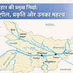
🌍 4. Rivers of India | भारत की नदियाँ
India is known for its large network of rivers.
भारत अपनी बड़ी नदी प्रणाली के लिए प्रसिद्ध है।
🔸 Major Rivers | प्रमुख नदियाँ
- The Ganga:
गंगा:- The Ganga River is considered one of the holiest rivers in India, flowing from the Himalayas to the Bay of Bengal.
गंगा नदी भारत की सबसे पवित्र नदियों में मानी जाती है, जो हिमालय से बंगाल की खाड़ी तक बहती है।
- The Ganga River is considered one of the holiest rivers in India, flowing from the Himalayas to the Bay of Bengal.
- The Yamuna:
यमुनाः- A major tributary of the Ganga, it flows through northern India.
गंगा की प्रमुख सहायक नदी, जो उत्तर भारत से होकर बहती है।
- A major tributary of the Ganga, it flows through northern India.
- The Indus:
इंडस:- Originates from Tibet, flowing through Pakistan and parts of India.
तिब्बत से उत्पन्न होती है, जो पाकिस्तान और भारत के कुछ हिस्सों से होकर बहती है।
- Originates from Tibet, flowing through Pakistan and parts of India.
- The Brahmaputra:
ब्रह्मपुत्र:- Flows from Tibet to the Bay of Bengal, through Assam.
तिब्बत से बंगाल की खाड़ी तक बहती है, और असम से होकर गुजरती है।
- Flows from Tibet to the Bay of Bengal, through Assam.
🌍 5. States and Union Territories | राज्य और केंद्र शासित प्रदेश
India is divided into 28 states and 8 union territories.
भारत को 28 राज्यों और 8 केंद्र शासित प्रदेशों में बांटा गया है।
🔸 States | राज्य
- Some major states include Uttar Pradesh, Maharashtra, Bengal, Rajasthan, etc.
प्रमुख राज्यों में उत्तर प्रदेश, महाराष्ट्र, बंगाल, राजस्थान आदि शामिल हैं।
🔸 Union Territories | केंद्र शासित प्रदेश
- Some major union territories include Delhi, Chandigarh, Lakshadweep, etc.
प्रमुख केंद्र शासित प्रदेशों में दिल्ली, चंडीगढ़, लक्षद्वीप आदि शामिल हैं।
🧠 Fun Fact | रोचक तथ्य
- India has two national capitals:
भारत के पास दो राष्ट्रीय राजधानियाँ हैं:- New Delhi – The official capital.
नई दिल्ली – आधिकारिक राजधानी। - Shimla – The summer capital.
शिमला – गर्मियों की राजधानी।
- New Delhi – The official capital.
Yes! Chapter 8: India – Climate, Vegetation and Wildlife | भारत – जलवायु, वनस्पति और वन्यजीव is the one we are about to explore. Here’s a detailed, bilingual (Hindi and English) analysis of the chapter:
📘 Chapter 8: India – Climate, Vegetation and Wildlife | भारत – जलवायु, वनस्पति और वन्यजीव
🌍 Introduction | परिचय
India’s climate, vegetation, and wildlife are diverse and influenced by the geography of the country.
भारत की जलवायु, वनस्पति, और वन्यजीव विविध हैं और देश की भौगोलिक स्थिति द्वारा प्रभावित हैं।
🌍 1. Climate of India | भारत की जलवायु
India has a varied climate due to its vast size and geographical diversity.
भारत की जलवायु में विविधता है, जो इसके विशाल आकार और भौगोलिक विविधता के कारण है।
🔸 Types of Climate | जलवायु के प्रकार
India has four major types of climate:
भारत में चार प्रमुख प्रकार की जलवायु पाई जाती है:
- Tropical Wet Climate (Monsoon Climate):
उष्णकटिबंधीय आर्द्र जलवायु (मौसमी जलवायु):- Found in coastal areas and western Ghats, with heavy rainfall during the monsoon season.
यह तटीय क्षेत्रों और पश्चिमी घाट में पाई जाती है, जहाँ मानसून सीजन के दौरान भारी वर्षा होती है।
- Found in coastal areas and western Ghats, with heavy rainfall during the monsoon season.
- Tropical Dry Climate:
उष्णकटिबंधीय शुष्क जलवायु:- Found in regions like Rajasthan and western India, characterized by hot summers and little rainfall.
यह राजस्थान और पश्चिमी भारत जैसे क्षेत्रों में पाई जाती है, जहाँ गर्मियों में अधिक तापमान और कम वर्षा होती है।
- Found in regions like Rajasthan and western India, characterized by hot summers and little rainfall.
- Subtropical Climate:
उपोष्णकटिबंधीय जलवायु:- Found in parts of northern India, including the Gangetic plains and Himalayan foothills, where the weather is neither too hot nor too cold.
यह उत्तर भारत के कुछ हिस्सों में, जिसमें गंगा का मैदान और हिमालय की तलहटी शामिल हैं, पाई जाती है, जहाँ मौसम न बहुत गर्म होता है और न बहुत ठंडा।
- Found in parts of northern India, including the Gangetic plains and Himalayan foothills, where the weather is neither too hot nor too cold.
- Mountain Climate:
पर्वतीय जलवायु:- Found in the Himalayas, with cool or cold temperatures, heavy snowfall in winter, and moderate temperatures in summer.
यह हिमालय में पाई जाती है, जहाँ ठंडी या बहुत ठंडी तापमान, सर्दियों में भारी हिमपात और गर्मियों में सामान्य तापमान रहता है।
- Found in the Himalayas, with cool or cold temperatures, heavy snowfall in winter, and moderate temperatures in summer.
🌍 2. Vegetation of India | भारत की वनस्पति
India has a wide variety of vegetation, influenced by its climate and geographical features.
भारत में वनस्पति की एक विस्तृत विविधता पाई जाती है, जो इसकी जलवायु और भौगोलिक विशेषताओं द्वारा प्रभावित होती है।
🔸 Types of Vegetation | वनस्पति के प्रकार
India has six major types of vegetation:
भारत में वनस्पति के छह प्रमुख प्रकार हैं:
- Tropical Evergreen Forests:
उष्णकटिबंधीय सदाबहार वन:- Found in regions like the Western Ghats, Andaman and Nicobar Islands, and coastal areas, these forests are dense and receive heavy rainfall throughout the year.
यह पश्चिमी घाट, अंडमान और निकोबार द्वीप, और तटीय क्षेत्रों में पाए जाते हैं, ये वन घने होते हैं और पूरे साल भारी वर्षा प्राप्त करते हैं।
- Found in regions like the Western Ghats, Andaman and Nicobar Islands, and coastal areas, these forests are dense and receive heavy rainfall throughout the year.
- Tropical Deciduous Forests:
उष्णकटिबंधीय पर्णपाती वन:- Found in central and northern India, they shed their leaves in the dry season to conserve water.
यह केंद्रीय और उत्तरी भारत में पाए जाते हैं, और ये शुष्क मौसम में पानी बचाने के लिए अपनी पत्तियाँ गिरा देते हैं।
- Found in central and northern India, they shed their leaves in the dry season to conserve water.
- Thorn Forests and Scrubs:
कंटक वन और झाड़ियाँ:- Found in desert areas like Rajasthan, these plants are drought-resistant and have thorns to conserve moisture.
यह मरुस्थलीय क्षेत्रों जैसे राजस्थान में पाए जाते हैं, ये पौधे सूखा सहनशील होते हैं और नमी बचाने के लिए कांटे होते हैं।
- Found in desert areas like Rajasthan, these plants are drought-resistant and have thorns to conserve moisture.
- Mountain Forests:
पर्वतीय वन:- Found in Himalayan regions, they vary with elevation, with coniferous forests at higher elevations and deciduous trees at lower elevations.
यह हिमालय क्षेत्र में पाए जाते हैं, ये ऊँचाई के साथ बदलते हैं, उच्च ऊँचाई पर ** शंकुधारी वन** और निचली ऊँचाई पर पर्णपाती वृक्ष होते हैं।
- Found in Himalayan regions, they vary with elevation, with coniferous forests at higher elevations and deciduous trees at lower elevations.
- Mangrove Forests:
मांग्रोव वन:- Found along the coastal areas of West Bengal and Odisha, these forests grow in saline water and protect the coastline from erosion.
यह पश्चिम बंगाल और ओडिशा के तटीय क्षेत्रों में पाए जाते हैं, ये वन खारे पानी में उगते हैं और तटरेखा को कटाव से बचाते हैं।
- Found along the coastal areas of West Bengal and Odisha, these forests grow in saline water and protect the coastline from erosion.
- Alpine Vegetation:
आल्पाइन वनस्पति:- Found in the Himalayan regions at high altitudes, consisting of mosses, lichens, and low-growing plants.
यह हिमालय क्षेत्र में उच्च ऊँचाई पर पाए जाते हैं, जिसमें काई, लाइकेन और कम ऊँचाई वाले पौधे होते हैं।
- Found in the Himalayan regions at high altitudes, consisting of mosses, lichens, and low-growing plants.
🌍 3. Wildlife of India | भारत का वन्यजीव
India is home to a rich diversity of wildlife, and its wildlife sanctuaries and national parks help conserve various species.
भारत वन्यजीवों की समृद्ध विविधता का घर है, और इसके वन्यजीव अभ्यारण्य और राष्ट्रीय उद्यान विभिन्न प्रजातियों के संरक्षण में मदद करते हैं।
🔸 Major Wildlife | प्रमुख वन्यजीव
- Royal Bengal Tiger:
रॉयल बंगाल टाइगर:- India is famous for its population of Royal Bengal Tigers, found mainly in Sundarbans and Jim Corbett National Park.
भारत रॉयल बंगाल टाइगर की आबादी के लिए प्रसिद्ध है, जो मुख्य रूप से सुंदरबन और जिम कॉर्बेट नेशनल पार्क में पाए जाते हैं।
- India is famous for its population of Royal Bengal Tigers, found mainly in Sundarbans and Jim Corbett National Park.
- Asian Elephant:
एशियाई हाथी:- These elephants are found in Assam, Kerala, and other parts of Southern India.
ये हाथी असम, केरल, और दक्षिण भारत के अन्य हिस्सों में पाए जाते हैं।
- These elephants are found in Assam, Kerala, and other parts of Southern India.
- Indian Rhinoceros:
भारतीय गैंडे:- Found mainly in Kaziranga National Park, Assam.
यह मुख्य रूप से काजीरंगा नेशनल पार्क, असम में पाए जाते हैं।
- Found mainly in Kaziranga National Park, Assam.
- Indian Leopard:
भारतीय तेंदुआ:- They are found across India, especially in forests like Sariska and Ranthambhore.
ये भारत भर में पाए जाते हैं, खासकर सारिस्का और रणथम्भौर जैसे जंगलों में।
- They are found across India, especially in forests like Sariska and Ranthambhore.
- Migratory Birds:
प्रवासी पक्षी:- India is an important destination for migratory birds, especially in areas like Sundarbans and Keoladeo National Park.
भारत प्रवासी पक्षियों के लिए एक महत्वपूर्ण गंतव्य है, खासकर सुंदरबन और केओलादेओ नेशनल पार्क जैसे क्षेत्रों में।
- India is an important destination for migratory birds, especially in areas like Sundarbans and Keoladeo National Park.
🧠 Fun Fact | रोचक तथ्य
- India has more than 500 wildlife sanctuaries and 100 national parks.
भारत में 500 से अधिक वन्यजीव अभ्यारण्य और 100 राष्ट्रीय उद्यान हैं।


Leave a Reply